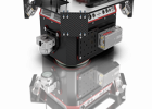
PIONEER P-360
Manufacturer: Phoenix LiDAR Systems
Description:
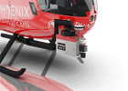
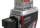
The Pioneer P-360 is a best-in-class universal survey grade LiDAR mapping system. With a measurement precision of <1cm, the P-360 will capture survey grade data for the most demanding application requirements. The complete system, with integrated dual oblique 24MPix cameras, weighs only 4.65kg; making it suitable for most mid-class commercial unmanned aircraft and robust enough for manned heli applications.
The Pioneer P-360 supports of wide range of operating parameters in pulse repetition rate, range, and lines per second to allow it to be optimized for the application and data requirements.
Features:
- Narrow beam divergence of <0.3 mrad 1/e2 for superior ground detection and canopy penetration
- Shot-to-shot precision of <1cm for survey applications
- Scan speed of 250 lines per second for even x-y point distribution at higher vehicle speeds
Specifications:
- Absolute Accuracy: 25-50 mm @ 350 m Range
- PP Attitude Heading RMS Error: 0.010° / 0.019° IMU options
- Weight (including Dual Cam): 4.65 kg / 10.25 lbs
- Dimensions (with Dual Cam): 382 x 160 x 120 mm
- Laser Range: 775 m @ 30% Reflectivity
- Scan Rate: 500 kHz, up to 4 returns
LASER
- RANGE MEASUREMENT PRINCIPLE: Time of Flight
- RANGE PERFORMANCE1: 775 m (50 kHz) to 300 m (500 kHz)
- PULSE REPETITION FREQUENCY: 500, 200, 50 kHz (Programmable)
- BEAM DIVERGENCE (1/E2) 0.3 mrad
- WAVELENGTH: 1550 nm
- LASER SAFETY CLASSIFICATION: Class 1
- LASER WEIGHT: 3.5 kg
- RANGE RESOLUTION: 2 mm
- INTENSITY RECORDING: 12 bits
- MAXIMUM NUMBER OF RETURNS: 4 (First, Second, Second Last, Last)
- MINIMUM RANGE: 1.5 m
- RANGE ACCURACY 1 SIGMA2: 10 mm
- PRECISION SINGLE SHOT2: 5 mm
SCANNING CHARACTERISTICS
- FIELD OF VIEW: 360°
- LINES PER SECOND (Scan Frequency): 50 – 250 lines/sec
ENVIRONMENTAL
- OPERATING TEMPERATURE (min/max): -10°/+40° C
- STORAGE TEMPERATURE (min/max) -20°/+50° C
- VIBRATION: DO-160H Section 8, Category S, Curve M
- SHOCK: DO-160H Section 7, Category A, Standard Shock
- DIMENSIONS: 310 (L) x 160 (W) x 116 (H) mm
- PROTECT CLASS: IP64 (Dust and splash proof)
POWER
- POWER SUPPLY INPUT VOLTAGE: 11 – 36V
- POWER CONSUMPTION: 60W
NAVIGATION SYSTEM
- CONSTELLATION SUPPORT: GPS + GLONASS + BEIDOU + GALILEO
- SUPPORT ALIGNMENT: Kinematic, Single-Antenna or optional Dual-Antenna
- OPERATION MODES: Real-time, Postprocessing optional
- ACCURACY POSITION: 1 cm + 1 ppm RMS horizontal
- PP ATTITUDE HEADING RMS ERROR: IMU 27: 0.019°, IMU 29: 0.010
1) 99% detection probability, 50 lines/second, 23km visibility, full footprint interception.
2) Max Range tested on flat targets, 50 lines/second scan speed, larger than the laser beam diameter, perpendicular angle of incidence and STD Clear visibility (23km).